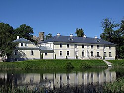
Padise Parish
Padise Parish
Padise vald | |
|---|---|
 Padise Manor | |
 Padise Parish within Harju County. | |
| Country | |
| County | |
| Administrative centre | Padise |
| Government | |
| • Mayor | Leemet Vaikmaa |
| Area | |
| • Total | 366.55 km2 (141.53 sq mi) |
| Population (2004) | |
| • Total | 1,771 |
| • Density | 4.8/km2 (13/sq mi) |
| Website | www.padise.ee |
Padise Parish (Estonian: Padise vald) was a rural municipality in Harju County, north-western Estonia.[1] It covered an area of 366.55 km2 and had a population of 1,771.
The administrative centre of Padise Parish was Padise village. It is located 47 km south-west from Estonia's capital, Tallinn.
History
[edit]The Padise name is first mentioned in the letter of the Danish king, which in 1283 confirmed the acquisition of the landed property for the future Cistercian Padise Abbey. In 1305 Eric VI of Denmark gave permission to the monks from Dünamünde to build a fortified monastery in Padise, the construction of which began in 1317. In 1343 - at the time of St. George's Night Uprising - the first floor and part of the main floor walls were finished. The monastery was burnt down and 28 monks, lay brothers and German vassals were killed. The rebuilding of the monastery began only after 1370 and the consecration of the main building took place as late as 1448. The monastery ceased to exist in 1559 during the Livonian War.
Local government
[edit]The mayor (vallavanem) was Leemet Vaikmaa.
Geography
[edit]Populated places
[edit]There were 24 villages (est: külad, sg. küla) in Padise Parish: Alliklepa, Altküla, Änglema, Audevälja, Harju-Risti, Hatu, Karilepa, Kasepere, Keibu, Kobru, Kõmmaste, Kurkse, Laane, Langa, Määra, Madise, Metslõugu, Padise, Pae, Pedase, Suurküla, Vihterpalu, Vilivalla, Vintse.
References
[edit]- ^ "X-GIS(4) Portal". xgis.maaamet.ee. Retrieved 2 February 2022.
External links
[edit]- Official website (in Estonian)
- Padise Map


